
Revive
Making boundaries and layers come alive as urban spaces. Connecting city, nature, and people in a new urban vision
Studio Topic | Urban Planning
Location | Tel aviv, Israel
Academic Year | Fifth Year , Final project
Between Tel Aviv and Holon lies a stretch of land considered marginally undeveloped, fragmented, and overlooked. Despite its central location and rich history, the area remains disconnected from the urban fabric. Yet its size, location, and complex composition offer a rare opportunity to reconnect neighborhoods, historic institutions, and emerging parks, while rethinking the encounter between nature and city.
My project proposes a new model of urbanity, where the city grows with the landscape and ground-level spaces are treated as meaningful urban elements.
Ultimately, the project serves as a local case study and a platform for broader metropolitan thinking, connecting space, belonging, and action, offering principles that can guide similar interventions across the region.
Conceptual Development

Creating New Space
The design encourages interaction within the space
Human Scale
Metropolitan Connections
Bridging Neighberhood &Park
Blurred Boundries
3 Stories Become One Project: A Shift from Metropolitan to Human Scale
FIRST STORY
Metropolitan Connection
Urban Analysis


Vision Board
As part of my design process i'm gathering images to create a vision board that follows my project inspiration.

Metropolitan Planning Strategies
Southward expansion of the metropolitan area


Transport intersection functioning as a connecing site
Restoration of the stream

Metropolitan Key Strategy
Design Principles
S


Current neglected Site
New Metropolitan Park Connecting the Cities
Mapping The Potential Of The New Urban Space

New Metropolitan Park | A Regional Connector
From Concept to Spatial Strategy

Reviving the River
New Park

Spatial Experience and Movement
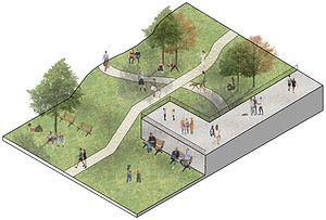
Perspective from the Park

SECOND STORY
When the Neighborhood Meets the Park
Ezra Neighberhood | Tel Aviv South


Neighborhood Planning Strategies
Design Principles

Multilayered Urbanity
Blending Levels and Programs Across Vertical and Horizontal Spaces


Landscape Integration Connecting the Neighborhood, the Park and the River
Renewing an Urban Resource
Connection to the Urban Fabric | A New Continuous Street Network
Urban Strategy


Urban Development Proposed Plan | Scale 1_2000
Ezra Neighborhood

Main Design Elements

Squares as neighborhood connectors

Ezra Neighborhood

Integration of green spaces into the neighborhood
Essential Design Components | Isometric Diagrams


Urban Section | Scale 1_1000
Ezra Neighborhood
Prespective from the stream to the new neighbohood

THIRD STORY
The design encourages movement within the neighbohood
Spatial Planning Strategies


Spatial Connectivity in Three Dimensions
Multiple Points of Encounters
The Ground Floor as an Urban Interface
Design Principles
The ground floor plan reveals a new way of thinking about the urban surface.
Rather than treating the ground as a closed footprint, the design reimagines it as a permeable and connected layer.
By leaving parts of the ground unbuilt, the project preserves an open public realm, allowing the landscape to flow freely between architecture and the city.

Neighbohood Perspective


A Continuous Open Space for Interaction
Ground Floor
The diagram illustrates a ground floor that is not defined as a closed boundary around the building, but as a dynamic urban space
Square Perspective


The City as a Continuous Landscape
Park Entrances
The diagram illustrates a space where the park doesn’t stop at the entrance of the buildings, but gently weaves into them, creating a continuous spatial flow.
Series of 3 Section
scale 1_500


Section no.2
scale 1_500


Section no.3
scale 1_500


In an area left to waste lies an urban heart in need of revivel that can bridge nature and community .
The decision to “open the ground” is not only a planning choice but a conceptual one.
Here, the park is not merely an added green space, but a primary axis of urban life.
The transition between neighborhood and park unfolds not only physically, but also perceptually.
The project’s guiding question is not “what to build,” but “how to build differently".
